Milford Track

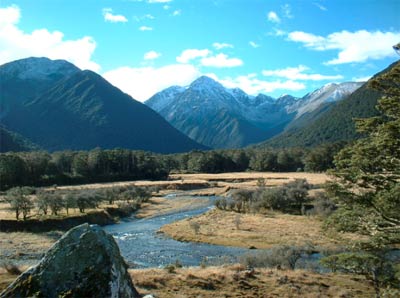
The Milford Track (53.5 kilometres) is in the heart of spectacular Fiordland National Park, part of the Te Wāhipounamu – South West New Zealand World Heritage Area and is administered by DOC on behalf of the New Zealand public.
You can walk the track independently or as part of a guided group. Ultimate Hikes hold the only DOC approved concession for overnight guided walks on the Milford Track during the peak walking season.Located in the southwest of the South Island, the track starts at the head of Lake Te Anau and finishes at Milford Sound. Te Anau, the nearest township has a full range of accommodation, shopping and hire services.
FEES: This is the MOST Expensive in New Zealand!!
Fees must be paid before you start the track.
If you are considering walking the track during the off-peak season please read the winter walking information.
| Peak season - booking required. | Off-peak - booking not required. | |||
|---|---|---|---|---|
| Adults (18+ yrs) | Youth/child* (0-17 yrs) | Adults (18+ yrs) | Youth/child* (0-17 yrs) | |
| Huts (all three) | $153.30 | Free (booking required) | $15.30 per hut | Free (booking required) |
Getting there
The Milford Track (53.5 kilometres) is in the heart of spectacular Fiordland National Park, part of the Te Wāhipounamu - South West New Zealand World Heritage Area, situated in the South Island of New Zealand.The Milford Track requires boat transport at both ends of the track. Bus or private transport is required to Te Anau Downs and also from Milford Sound.
During the summer there are regular transport services to and from the track.
Road distances and times
- Te Anau to Te Anau Downs - (27km) 30 minutes
- Milford Sound to Te Anau - (120km) 2 hours
- Milford Sound to Divide - (35km) 30minutes
- Queenstown to Te Anau - (197 km) 2 hours
- Invercargill to Te Anau - 1 hour 45mins
Track description
The track is marked with “Mile Posts” and there are very good guide books giving detailed information on a mile by mile basis, available from the Fiordland National Park Visitor Centre.Times are approximate and will vary according to fitness, pace of the group and weather conditions. Each evening DOC staff at the huts will give a safety briefing talk.
Day one, Glade wharf - Clinton hut
Time: 1 - 1 hr 30 minDistance: 5 km
After a launch cruise from Te Anau Downs (1¼ hours approx) there is a one kilometre walk to Glade House, the first overnight stop for guided walkers. Just past Glade House is the largest and the first of the nine suspension bridges you will encounter on your trip. On a fine day this is a pleasant lunch stop.
Independent walkers continue on the track for about one hour, through attractive beech forest along the banks of the Clinton River, to the Clinton Hut. There are good swimming holes near the hut and a side trip around the wetland board walk.
Guided interpretation trips may be available during the late afternoon, depending on the track staff’s commitments.
During the booked walking season the first night must be spent at Clinton Hut, as the previous day’s walkers will be at the next hut at Mintaro.
Day two, Clinton hut - Mintaro hut
Time: 6 hrDistance: 16.5 km
It is a gradual climb from Clinton Hut as the track follows the Clinton River to its source, Lake Mintaro, at the base of Mackinnon Pass. It passes through sections of forest and crosses many streams, which may need to be forded during or after heavy rain.
The track passes through many avalanche paths. There are 56 such paths along the track which can cause delays or make the track impassable at any time, especially during the September to early November period. These are sign posted during the danger season. Use caution at other times as dictated by the weather.
An hour from Clinton Hut you reach the Clinton Forks. The toilet located there is all that remains of what was once the first night’s stop for Independent Walkers. The changing course of the river eroded the site.
About 40 minutes further on is a large slip, which occurred in 1982, forming a lake behind it. From here to Hirere Falls (about 20 minutes) the track is prone to flooding during heavy rain. There is a toilet at the Hirere Falls Guided-Walk Shelter. Not far from this point you will get your first view of the Mackinnon Pass and the Pompolona ice field.
It is about an hours walk from Hirere Falls to Marlenes Creek, which can cause problems during heavy rain. The Bus Stop Shelter is located just before the creek and a toilet is located just past the creek.
After passing the turnoff to the guided walks Pompolona Hut, there is a short climb before descending to cross a swingbridge. It is approximately 1½ hours from here to the Mintaro Hut. The vegetation starts to change, reflecting the higher altitude and rainfall. After re-entering the bush it is approximately 40 minutes to Mintaro Hut. Walkers must stay here the second night during the Great Walks Peak Season.
Day three, Mintaro hut - Dumpling hut
Time: 6 - 7 hrDistance: 14 km From Mintaro Hut there is a well-graded, steady, zigzag climb of about two hours to the Mackinnon Memorial. On the way there are excellent views of Lake Mintaro and the Clinton Canyon. It is worth stopping for a few minutes at the memorial to take in the view from the 12 second drop, before commencing the final climb to the highest point of the track and The Pass Day Shelter (1069 metres).
It is about a twenty minute walk from the memorial to the shelter. The toilet with the best view in Fiordland is located near the shelter. The shelter is supplied with a gas-cooking ring during the summer season.
The 8 km walk from the pass to the Dumpling Hut drops 970 metres steadily over rocky, uneven terrain and provides spectacular views. For many walkers this is the most difficult part of the track. Take regular five minute rests on the down hill section, your knees and ankles will be very grateful!
The Moraine Creek Bridge, the first bridge crossed on the descent, is approximately a third of the way down to Quintin Hut turnoff. Shortly after, the track follows the river, on which there are several waterfalls. This section of the track has wooden boardwalk and staircases in a number of places until it crosses the Roaring Burn swing bridge.
The track then continues to follow the river, with the Dudleigh Falls located about two thirds of the way down. A set of rocky and uneven zigzags leads to the bottom of the hill. From here you can turn left and cross the bridge to the public shelter, toilet and Sutherland Falls or turn right to Dumpling Hut.
The side trip to the Sutherland Falls is well worth the effort. Leave your pack at the Quintin Public Shelter and take the track on the left to the Sutherland Falls - about 1½ hours return. From the shelter it is about an hours walk to Dumpling Hut. There is an excellent view behind you of the Sutherland Falls, about 20 minutes along the track to the Dumpling Hut.
Just before reaching Dumpling Hut there is a raised boardwalk. After dark this is a good place to spot glow worms. A good swimming hole can be found just opposite the turnoff to the huts.
Day four, Dumpling hut - Sandfly point
Time: 5 hr 30 min - 6 hrDistance: 18 km Most walkers will be feeling the effects of the previous day’s walk. In the main hut there is an excellent track time/place guide that is well worth noting. The track gently descends, following the Arthur River for about 1½ hours to the historic Boatshed. A toilet is located here.
After crossing the swingbridge, the second largest on the track and a good place to spot trout and eels, it is about 20 minutes to MacKay Falls and Bell Rock. Bell Rock is an intriguing rock, which has been worn by water and grinding stones and then tipped over in a rock fall. An hour further on the track crosses two suspension bridges at Poseidon Creek.
The rock cuttings alongside the Arthur River and around Lake Ada were blasted out by prison gangs and contracted work parties in the late 19th century. About an hour later are the Giant Gate Falls. There is a shelter and toilet located beside the river and falls, making it an ideal lunch stop.
From here it is about 1½ hours to Sandfly Point. Flooding can cause delays through this section of track. If the track is closed Department of Conservation Staff will notify walkers during the peak season.
During the Great Walks peak season you will need to leave Dumpling Hut between 8.00 am and 9.00 am, to meet with the boats departing at either 2.00 pm or 3.15 pm from Sandfly Point to Milford Sound. The boat crossing takes approximately 20 minutes.
Closest Towns:
Te Anau - Milford Sound